How the Kochi Ithile Wayfinding Signages Improved Public Access Through Information Systems
“Not to find one's way around a city does not mean much. But to lose one's way in a city, as one loses one's way in a forest, requires some schooling. Street names must speak to the urban wanderer like the snapping of dry twigs, and little streets in the heart of the city must reflect the times of day.”
- Walter Benjamin, Berlin Childhood in the 1900s (1932)
In our digitally connected world, navigating an unfamiliar city is no longer an unsurmountable challenge. However, incorporating wayfinding practices like making basic information easily available in the form of maps, allows people to experience a city, not just pass through it. Making practical information like bus / metro timings, etc readily available nudges people to opt for public transport, walking and cycling, catalysing the transition from private vehicles to low-emission forms of transit.
Kochi, located on the south-western coast of India, is a vibrant cultural hub, which blends different natural landscapes (backwaters, canals, and green cover). Being a tourist destination and an important commercial centre of the state, it has a significant inflow of people including migrants and domestic and international tourists, all of whom stand to benefit greatly from access to useful information.
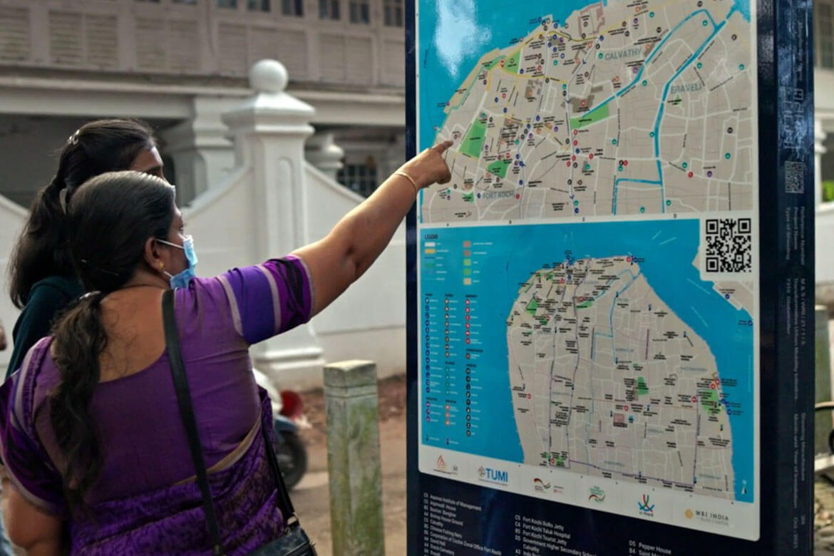
The Reimagining Fort Kochi project, developed under the Transformative Urban Mobility Initiative, aims at improving accessibility in and around the historic Fort Kochi-Mattancherry area. The region was considered as a test bed for the pilot initiative owing to its walkable scale and a concentration of points of interest for tourists and locals. The project incorporated Kochi Ithile (Kochi this way) wayfinding signages as both digital and static maps, and an online portal (www.kochiithile.com) to make the area more accessible to all.
Based on our learnings from this pilot project, here are a few key considerations integral to developing a successful wayfinding system in Indian cities:
i. Understanding User Perspective
Understanding the exact kind of information people need is key to creating an equitable solution that caters to people of diverse backgrounds. Since Kochi is a melting pot for locals and tourists alike, access to information that is of relevance to both sets of people is important. Kochi Ithile carried out active and on-ground engagements with city authorities, elected representatives, resource persons etc to gather and present localized information to its users.

ii. Choosing the Right Medium
Wayfinding signages vary in their form (print or digital) based on factors such as information type, geographical area to be served, budget, and ground realities such as security, access to services, etc. Printed signages accommodate limited information and are user-friendly, low maintenance and easily installable. On the other hand, digital signages can provide comprehensive information, including real time updates but cost four times more than their physical counterparts. Unlike printed signages, these require electricity and internet and need regular updating and maintenance. Kochi Ithile combined print (80%) and digital (20%) signages along with Kochi Ithile website and mobile application to deliver its best overall outcome.

iii. Making Information Legible
Information legibility and access are equally important. Only then can users locate themselves, their destinations, and directions on the map, and relate what they see with the actual surroundings. The Kochi Ithile has a ‘You are here’ location indicator for user orientation, walkable grids (200-500m depending on the context), legible fonts, colours and icons, as well as information in both English and Malayalam.

iv. Selecting Strategic Locations and Placement
Signages need to be located at regular intervals to create a network that guides users. This may be determined by a thumb rule of at least one signage within a grid of 500m, which is 5-10 min walking distance. The signages may be installed on footpaths in an alignment allowing maximum visibility and access to the users, without obstructing the movement of pedestrians. The size and shape of the signage should be determined based on availability of space, nature of information and applicable rules and regulations. Kochi Ithile provided two variants of printed signages with varying widths, based on space availability on footpaths.

v. Getting Consensus Among Stakeholders
Consensus among concerned agencies, local administration and locals is critical to avoid any possible conflicts. Kochi Ithile carried out recces to examine on-ground scenario and involved stakeholders in data collection, validation and finalizing locations for the signages. Involvement in the process was designed to evoke a sense of responsibility in maintaining the signages.

vi. Associating With Government and Key Decision Makers
Stakeholders like the municipal corporation and government authorities have a substantial role in providing approvals for design and implementation, validation of land, provision of services, signage upkeep and scaling up in the rest of the city. The Kochi Ithile associated with Kochi Municipal Corporation, Centre for Heritage, Environment and Development and various other city authorities like Department of Tourism, State Water Transport Department, Kerala State Road Transport Corporation and Greater Cochin Development Authority throughout the process of signage development.

vii. Developing a Scalable Model
Wayfinding plays an important role in improving walkability in cities. Scaling it up to more places would create a widespread impact. The signages must be developed adhering to certain design standards to ensure visibility, legibility and uniformity while scaling up within the city. Cities can also develop and maintain a signage design manual that can guide other cities as well on the design and process of signage development.
Today, the Fort Kochi-Mattancherry area has a network of 25 wayfinding signages which are helping people explore this historic district in a more meaningful manner. The city has taken ownership of these signages and continues to maintain them. This has also created an opportunity to scale up the signage network to rest of the city, which can in turn make the city more accessible and equitable.
For further details about Kochi Ithile please refer to the Reimagining Fort Kochi - Wayfinding Signage Manual. The wayfinding signages were jointly implemented under the leadership of Kochi Municipal Corporation (KMC), Centre for Heritage, Environment & Development (C-HED), in collaboration with SMART SUT project of GIZ India. The pilot project was funded by German Federal Ministry of Economic Cooperation and Development and contributes to the Indo-German Green Urban Mobility Partnership.
Views are personal.